Friday, 15 March 2019

Shawnee Forest hikes

After my muddy run at Land Between the  Lakes I did some short hikes in Shawnee National Forest in southern Illinois. My first foray failed: I drove a bunch of back roads trying to reach the Rim Rock area in the western part of the forest and after a lot of messing around and having to retrace my route I ended up on a road leading directly into a lake. The lake must have expanded with the flooding. 

The next day I took a better route and was able to hike the Indian Point Trail and the Rim Rock Trail, with add-on to Pounds Hollow. Both were in the deciduous forest and featured huge rocky bluffs pitted with holes. The trails went right under the bluffs. There were some impressive caves dripping away, and balancing rocks. The Rim Rock Trail came highly rated but I was alone there. I continued beyond the major rocks to the lake at Pounds Hollow. The lake was pretty but the beach looked rather forlorn, damp and deserted, although capable of holding a big crowd in high season. On the return to the car park the trail led between boulders on some startlingly narrow trail where even I could barely squeeze through. Is that why no one was there?

The second day I went to Giant City State Park and did two trails, Giant City Trail and Trillium Trail.  All these trails are hard to find even though the car park sizes suggest they expect loads of visitors. There were a few people around today and nice wintry forest. I like the thick carpet of brown oak leaves and that you can have views when there aren’t leaves on the trees to block everything out. Plenty of squirrels. The Trillium Trail climbed above a little creek.

I kept the highlight of the Shawnee Forest for the last day when I did the Little Grand Canyon Trail. Perhaps an overstatement to liken this area to the Grand Canyon but the trail was great. I started with a fairly level mile through the forest to a lookout from the top of a bluff towards another bluff. Below was a muddy river and much indication of flooding. There were a couple of guys there who were doing my loop in the opposite direction.

From the bluff I continued, descending gradually towards that same river, when I lost the trail and found myself among the undergrowth. I could not see where to go as the trail just stopped. But I did know the loop was possible since I had seen those guys. With the help of GPS on my phone I rejoined the trail and saw the sign that I had missed pointing towards a major descent on rock to the valley floor. This trail had come with some warnings, and as I clambered down I could see that, following rain at least, the warnings were not exaggerated. The rock was extremely smooth and slippery with lichen and water flowing all over it. This was actually quite hard going but lovely: the overhanging rocks of the canyon, mosses, little waterfalls, sounds of trickling water, pools. 


At the bottom I was back to dry forest, albeit somewhat muddy. I crossed a few creeks and wound through the trees, then had an ascent similar to my descent. Except that I didn’t miss the signs and the ascent was pretty much straight up a waterfall. When I found myself on the wrong side of the waterfall it was hard to cross it to reach a better path. Then I walked back to the car. It was an odd contrast, the dry forest and the very wet canyon. My trail shoes had dried out from LBL but are now soaked through again.

Monday, 11 March 2019

Land Between the Lakes 60 km ultra, Kentucky


The day before this race I decided to go for a short run in the same area as the race, but further into the park called Land Between the Lakes where we were going to run. There had been a lot of flooding in this part of Kentucky and all week I had been getting emails about what the race organisers were doing to ensure we could run the race despite many of the trails still being waterlogged. Soon enough I saw what the problem was. I was intending to run the Honker Trail around a small lake. When I parked the car it was raining so I coated up and set off; there was nobody else around. I ran down an access trail and found my Honker Trail. Within twenty metres the trail disappeared under water and I could not see it emerging ahead. So I ended up running on 4WD roads and wound a nice, muddy, out and back route in forest to a further away point on the lake shore.

Afterwards I had to go to Waffle House to get warm. In the afternoon they were forecasting heavy rain and strong 40 mph winds with the possibility of a tornado for race day. I was also worried about which time zone I was on because Kentucky is one of those states on two time zones and I didn’t want to get to the race an hour early.

In the end we didn’t get the tornado but we got a lot of rain, a big thunderstorm with plenty of lightning and the muddiest run I have ever done by a long shot. Yesterday’s mud was nothing on this. This mud was yellow or brown and slippery. Very slippery. I saw runners falling all over the place and I was amazed that I never fell once. The thick leaf litter compounded the slickness of the trail and made the myriad obstacles (roots, sticks, hollows) hard to spot.

I found the race mentally demanding since I had to pay attention the entire time, no zoning out was possible or I might trip. It was like skiing in this respect. But for eight hours straight.

The trail was a single track and passing was impossible unless the person being passed stood aside. I found everyone was so kind about this irritation. I had deliberately started near the back and in the later stages I had to pass people.

It rained lightly at the start but nothing serious enough for a rain jacket. We had a brief run on the road from Grand Rivers (where I had managed to stay even nearer the start line than last weekend) then turned into the Land Between the Lakes National Recreation Area and commenced three laps of the Canal Trail. 

The mud was an issue from the very start and we all hoped that this early part was just a muddy stretch, but it never went away. On the first lap it was possible, occasionally, to avoid some of the mud by stepping off the trail but later this just made the mud patches expand. The worst was when there was grass beside the trail because the grass became impossibly slippery too and there was nowhere to go. Many of the hairpin bends in the trail were tricky too, especially on downhills, because of the camber combined with mud. I’m not making excuses here, it was a difficult day.

I was immediately concerned that this race was going to be rather monotonous, winding through the leafless forest on a grey day. But soon I realised we were going to have lots of lake views - we were on a peninsula with a lake on either side which meant we had water to our left the whole way around the loop - and the route wended its way around many inlets. There were little grassy clearings too. I believe there’s interesting wildlife on a nice summer day. Unfortunately the receding flood waters had left a lot of rubbish among the trees which was very unsightly. The trail was undulating with some more marked hills in the latter part; all runnable although I allowed myself to walk a little.

There were four aid stations around the eleven mile loop. This was unusually frequent for a trail race and very welcome. All had cheering marshals for whom the bad weather day must have been most unpleasant. I ate cookies, pb&j sandwiches, and - just once - a bean and cheese tortilla segment. After all these races I still think you can’t beat a homemade pb&j.

The first real rain came very suddenly at 9.30, three hours in. It was torrential and I was soaked by the time I got my jacket on. But it stopped equally suddenly and I was left wondering if that was it. I kept my jacket on and got far too warm, so eventually I took it off, hoping not to bring on the rain. There was no noticeable effect on the mud, except that it clearly wasn’t going to be able to dry out. Looking out at the lakes there was a lot of mist and I could no longer see the far shores. 

Two hours later the real rain started. Not quite as heavy but this time it wasn’t going to stop. Then as I started my third lap there were major sheets of lightning followed alarmingly soon by thunder claps. I was glad I was still down low rather than on the ridge. This lasted for maybe half an hour and then we were back to just moderately heavy rain.

This heavier rain had the effect of turning the single track into a rivulet, yellowish flowing water marking our route. It was actually easier to run through the water rather than try to avoid it as the footing was firmer underneath, but the water was too cold for comfort, and it was only in the last half of the loop that I ran through the water with abandon as I knew I would soon be done. However, parts of the second half of the loop which had been marginally less muddy than the rest of the trail had become very slippery so the moments of respite were gone. Running through the water had the strange effect of cleaning my shoes. They had been totally mud covered, unsurprisingly, and I had been looking forward to photographing them, but now they were clean.

Coming back onto the paved road for the final two miles was a relief but I was so tired I had to walk some bits. There were two long bridges and then a brief climb back into the town. I wanted to break eight hours, in fact I had never doubted being able to do this, but I missed by a minute. Who cares? It was enough to be able to look forward to an imminent hot shower. 


I had hot chilli and coffee (and more pb&j's) in the community centre, and then I walked a short distance to my room. It was amazingly windy, almost scary. After I had my shower I looked out the window and the sky was largely blue with the sun shining. Unbelievable!

Thursday, 7 March 2019

Monument Valley 50 km ultra, Utah/Arizona


An unusual race in an unusual place. Monument Valley is an American highlight, with huge red sandstone formations that look like imposters standing up in isolation among the red earth canyons and low bushes of the high desert. Time now to brush up on geology. There are mesas, buttes and needles. The bases, like pedestals, look crumbly but the upper parts are solid rock. This area has featured in many movies, mainly Westerns, and this is where Forrest Gump decided to stop running. I thought the race was in Utah but we were running in both Arizona and Utah on Navajo tribal lands, using several trails that can normally only be used in the company of a Navajo guide, and climbing to the top of a mesa on a trail that is only used once a year during this race.


The main challenges of the race were going to be the almost constant running on sandy surfaces, fortunately damped down a little for us by recent snowfall, and the steep climb to the top of Mitchell Mesa starting late in the race at Mile 23. The snow had come and gone apart from a few traces on the rock faces but it had left plenty of mud, some very slippery. There were many Native Americans, male and female, in the races and a handful of other foreigners. 

It’s been a long time since I slept so close to the start line of a race (2011 at Mt Sneffels marathon I think) and it was great to walk there in a couple of minutes. Again I had been unsure how to dress because I didn’t think it would be really cold, and I had overdressed last weekend, but rain was forecast and I knew the morning would start out cold. I had thought I should wear knee socks and my new gaiters to prevent too much sand getting into my shoes, so I accompanied these with shorts and T-shirt, wrapped my rain jacket around my waist and wore arm warmers and gloves. I didn’t take my hydration vest as there would be frequent aid stations.

After a flag raising ceremony with a Native American and an American, and a prayer by a local, we were on our way. We ran towards and the between the pair of buttes called the Mittens (East and West) because they look like giant mittens. We also passed other rocks and undulated in a big loop, crossing dry gullies and passing a lot of prickly bushes before returning near the start. It was mostly single track and I settled into a position fairly near the back, or at least I thought that was where I was. It was overcast and I was certainly warm enough in just a T-shirt.

I wasn’t feeling amazingly strong but I guess that was due to the altitude, as we were up at about 2000 metres. You don’t realise it when you aren’t conscious of climbing. The car had done all that work. 

The aid stations were fairly basic and most people weren’t stopping at the early ones as they had their own supplies. I made an effort to drink because the dry air would be more dehydrating than my thirst would indicate. Later on they had some hot food, including quesadillas which got me very excited until I ate one and discovered it was filled with that nasty processed cheese.

After our 13 mile loop we headed out in the other direction, running through the area that I could see from my hotel room. At first we were on the tourist road through the valley, a dirt road, and I ran several miles with a guy from Montana. It was a long downhill, fun except that we would be returning later on this same road. One consolation was that the downhill was into the wind, which had picked up. 

We detoured off this road to run around a tall mesa, a muddy trail which felt very remote. In the distance we could see parts of the park where tourists can only go with a guide, mainly long mesas and some natural arches. We returned to the road and passed a tall needle, and arrived at the Three Sisters aid station. The Three Sisters are a set of needle formations intended to resemble a nun and two protégées rather than three siblings.

From here we embarked on our jaunt towards and up Mitchell Mesa. The access trail seemed very long to me, a gradual uphill with no end in sight and definitely the most nondescript part of the race route. The lead runners were already returning. It was about three miles to the start of the real climb and I was looking forward to it even though I had been told it would be hard. I had a cup of water at the base.

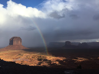
The climb was awesome. We were sort of inside the mesa, on the inside of its curve, and it was other worldly. The trail was sandy and rocky, becoming increasingly rocky, and very narrow. I passed a few people and was able to run some of the less steep parts. I felt a lot better than I had felt on the access trail. When we got to the top I thought we were done, but we had about twenty minutes of running to the far end of the mesa through low scrub. It was absolutely freezing on top (someone later said it was twelve degrees F but I think that must be an exaggeration). The best views came at our turnaround where we could see all those unique monuments. The marshals at the turnaround had a little fire going and some runners lingered to take photos. I was more concerned about the impending rain.

At 12.57pm I muttered (joking) to another runner that the rain had been forecast to start at 1pm so clearly rain is unreliable. At 1.10pm it started raining. It was only sprinkly at first and I barely noticed it. I knocked my shin on a rock and it was surprisingly painful. 

By the time I reached the base again and started on the access trail the rain was coming down harder. I didn’t want to put my jacket on because I thought I might get too warm and I set myself the goal of reaching the Three Sisters aid station before putting it on. But I didn’t make it; the rain became heavier and I felt quite cold. This return on the access trail also seemed very long, but I also realised I must be dehydrated from only having one cup of water in ten miles. Along here I realised that I was not near the back of the field at all as runners heading for the mesa were still coming.

When I got to the aid station there were lots of people huddled under a dripping tarp. The ground was a quagmire. I didn’t linger, I just had two cups of drink and grabbed some sour worms and Oreos and headed off. Again I don’t think I had been eating enough but I just can’t seem to get my nutrition sorted. Although several women had passed me on the descent from the mesa I left them all behind at this aid station. It wasn’t deliberate, I was cold and wanted to keep moving.


I had promised myself that I could walk intermittently from here the last three miles to the finish, especially as it would be mostly uphill. But in the end I ran virtually all the way. I was nonplussed to see no other runners ahead or behind me, until I spotted someone a long way ahead. I shortened the gap but failed to close it completely. The road was a sea of mud. I was trying to break seven hours again but it was appearing increasingly unlikely. Before the race I had thought this would be an eight hour race, based on prior results, but near the end I sensed it should be faster than that.

When the hotel came into view I was relieved as I knew I was almost done, but there were tortuous hairpin bends to negotiate before the finish line. Luckily I made my goal, finishing in 6:47, all the sweeter because I measured the race at 54 kilometres. 

I had won my age group which earned me a pottery vase and a $100 voucher for the hotel gift shop. I was ninth female overall. They had hot food at the finish line so I carried some Navajo stew and flat bread back to my room. The finish line area was a washout and not pleasant to hang around. It was hard carrying the bowl of stew, cup of coffee and my vase, and then I had difficulty opening my door with such cold hands. After a hot shower I felt normal again and the stew was absolutely delicious.


Monday, 25 February 2019

Salmon Falls 50 km race, Folsom, California

A race out on the trails rather than around a track! I was disappointed they had no record of my registration at packet pick up but there’s a first time for everything and this was soon rectified. It was the usual pleasant American set up for a point to point race: park, take a school bus to the start and chat comfortably with a stranger, hang around in the cold with braziers to huddle around. I had spent a great deal of time wondering what to wear for the cold, wondering exactly how cold it would be, and whether I should take my hydration vest. In the race photos almost everyone wore a hydration vest but I couldn’t see the need as there would be seven aid stations. In the end I wore mine. I just don’t like it when lots of people comment on my not carrying any gear. I wore knee length tights and took a lightweight jacket plus a very small emergency supply of water to justify wearing the vest.

We were a crowd of around 300. It was close to freezing at the start and it took me nine miles to warm up enough to take off the jacket. When I took it off, at an aid station, one marshal tried to help me get the sleeves over my hands and another marshal even offered to roll it up for me to put in my pack; race marshals here are beyond helpful. The sun came out and it was a perfect running temperature.

The first thirteen miles was in a state park and was lovely. We climbed above one fork of American River and loosely followed it, running trails over rolling bald hills. The water shone in the early morning light. There was plenty of frost and later on mud. Nothing was flat but the hills were not severe and I tried to run them all, while most people around me walked the uphills.

Just before the thirteen mile aid station we crossed the river and passed the Salmon Falls right by the bridge. I’m afraid they were not that special. Approaching the bridge we had a twisting downhill which had been mentioned on the race website as being difficult and I had worried about it before the race, but at the time of running down I was not even aware this was it. A runner ahead of me tripped over; I hadn’t seen it happen but the two of us had been playing cat and mouse for a while and as I drew level with her I said, sympathetically, That’s usually my trick which must mean something else here because she clearly wasn’t impressed by my turn of phrase.

After this we basically ran alongside Folsom Lake. I ran sandwiched between two other runners for a long time; they were walking the short uphills and running the downs and I would draw even with the woman in front on the uphills then drop behind on the downs. The man behind me was one of only two runners I saw not wearing a hydration vest and I had a strong desire to talk to him about this, but didn’t.

The path, mainly singletrack, wound along through light forest, sometimes more open grassland, with a lot of muddy sections and a couple of stream crossings where you could not avoid getting wet feet. The water was cold but refreshing. All of the track was either up or down, I don’t think any of it was actually flat. The lake was big with steep sided gravel banks and there were a few motor boats, but there was little access to the water. I had passed the two runners I’d been running with but then the guy without a hydration vest reappeared and passed me and I followed him for quite a while. I had already been passing quite a few people but feeling really comfortable. My main goal was to beat seven hours. 

About six miles before the finish we came into lightly populated areas, and some noisy dogs. A local woman welcomed me to her neighbourhood and said to look out for eagles. They had cold brew coffee at the last aid station; it was great and gave me a real lift. I passed no-hydration-vest. In the final mile we had to run across the Folsom dam. This was a definite low point, much longer than the dam wall at Lysterfield, although flat. 

They were announcing names in the finishing chute but did not mention me; I immediately worried this was due to my registration mess up and went straight to the woman who was looking after results. She confirmed I had won my age group in 6:20; when the second placer finished (it turned out I had passed her in the final three miles) we stood on the podium for photos. I later realised they had not called out my name because my race bib was covered up.

While I was hanging around no-hydration-vest came up to say hi. I still didn’t take the opportunity to compliment him on running without a vest. I was surprised to see in the results he was the same age as me.

There was a huge picnic area by the finish. Given a choice of cheeseburger or vegetable soup I had to have the burger, my first beef of the year. It tasted good and I can see why people eat beef. 

I went back to the hotel for a shower. I had thought I wasn’t feeling too tired but once I got there I didn’t want to go out again. I had snacks from the vending machine for dinner, my post race beer and a lot of TV.


In other running, I had been very pleased to run the Dipsea trail from Mill Valley to Stinson Beach the day after I arrived here. Once I reached Stinson Beach I had intended to get the bus back to Mill Valley but there was no bus for three hours. I got a coffee and chatted briefly to another customer (who was almost blind I noticed after a while) who recommended I run the Steep Ravine Trail. So I did this and it was great, through the heart of the forest and by a creek. I emerged at a roadside picnic area and once again thought I could get the bus but there was still a long wait and I was cold, so I went on and ran all the way back to Mill Valley, arriving before the bus.

Saturday, 16 February 2019

Trail run from Belgrave


was looking at the map to find somewhere new to run and I noticed how there is a fat crescent of green in Melbourne's south east; I’ve often run in various parts of the crescent but I haven’t attempted to link the parts, so a run from Belgrave at one end to somewhere at the other end was in order, using public transport at each end. It wasn’t a new place to run but it was a different run. The parts were: Lysterfield NP (which is in two sections divided by Wellington Road and I only ever run in one section at a time), Churchill NP, Police Paddocks Reserve, Dandenong Creek corridor and Tirhatuan Park.

It was a very nice run on a still Friday morning, starting out cool and becoming hot by mid morning. From Belgrave I took the quaintly named Lovers Lane and then the road alongside a creek down towards Birdsland. The lake there was still with a few swamp hens strutting about. I saw plenty of kangaroos on the Birdsland side of Lysterfield, and in a stroke of brilliance I made a last minute decision to run the (hilly) Granite Track so that I could cross busy Wellington Road at the lights, rather than where the Dargon Track and Logan Park Road meet, where I know from driving to Lysterfield that it is virtually impossible to cross on a weekday. I’ve never run the Granite Track in this direction and it was much easier than going the usual way, far less steep.

I did some different trails in the other half of Lysterfield and did some usual trails in the opposite direction. Despite an overall downhill route I still had a few uphills. I passed only one bike and a couple of runners. It was all lovely in the sunshine. The Glen Track was completely dry which is unusual. I especially liked running down the Lysterfield Hills Track rather than up. When I got into Churchill there were more people around and less wildlife. 

My first mess up came in Churchill NP: I thought I could get to the Police Paddocks without running along busy Churchill Park Drive but I found a high fence in my way on the route I had worked out from the map, so I had to backtrack and then run along the road for a while. I could run off the road but this meant running through a series of rubbish dumps.

The Police Paddocks are more open with sparse pine trees. The path did not feel as though it was much used. There was an interesting cairn with a full history of the reserve from 1851 onward, including notes of the police employing native trackers and visiting dignitaries planting pine trees. I stopped to eat some blackberries and a few metres further on saw some rangers who were spraying all the bushes. I hope they hadn’t yet reached the ones I ate from. When I left the reserve and joined Dandenong Creek I initially went in the wrong direction, going under the freeway when I should have been at Stud Road, but it was pretty. The creek was flowing nicely and there were horses in the paddocks.

I rectified my mistake and went the right way along the creek, eventually going under Stud Road. It was hot by now and there was no shade. I wasn’t quite sure where I was going to end up, but when I emerged onto a suburban street at the far end of Tirhatuan Park I saw a bus stop fairly soon. Even better, the bus was due in three minutes so it all worked out well. A very pleasant 24.8 kilometres.

Thursday, 14 February 2019

Leanganook Trail hike 11-13 Feb


I needed to take my new tent out for a spin. Since I also wanted to meet up with Sophie while she’s in Bendigo, and I wanted to use one of my Seniors free train vouchers, I was very pleased to find the 60 kilometre Leanganook Track between Castlemaine and Bendigo, thus killing not two but three birds with one stone.

So I took the train to Castlemaine and went hiking. The first bit was boring, but once I got into the forest and reached the Garfield water wheel remains things looked up. The water wheel brickwork was huge and I ate lunch while studying it. Then I found myself walking around in a circle and visited the same site again. This was the only time during the hike that I got lost; it was my fault as I had not looked at the marker sign carefully, and in fact the trail was well marked all the way.

Later in the afternoon I entered the Mount Alexander Regional Park and this was the highlight of the trail. I had to climb a bit in light forest and there were huge granite boulders all around. I surprised a large pack of kangaroos and saw lots of parrots. There were good views over the countryside, and on the first high point (which I initially thought was the peak) there was an elaborate timber bench/chair for comfortable viewing. Shortly after I detoured to the Leanganook picnic area and campsite for the night, 20 kilometres hiked.

This was a low key campsite and I hid myself among the trees. There seemed to be one other person staying there and sleeping in a ute, which spooked me a little, but I felt I was camped out of sight. In the night the wind picked up and was really noisy but I slept ok.

The hike continued to be great for the morning, with masses more of the large boulders, and I reached the top of Mount Alexander and its TV tower. It was very windy and also felt about to rain.

I descended for a while and got to the Coliban water channel, apparently an engineering marvel from Victorian days, but in reality a narrow and fast flowing water course with high concrete sides. At this point I must note that water availability on this trail was an issue; I wasn’t sure if there would be any water sources so I had brought three litres with me which is more than I would usually carry. I hoped I would find somewhere to refill, and when I read about this water channel I wondered if the water would be accessible to me or if I would be seeing it but unable to help myself to any. The latter soon seemed to be the case, as I could not reach the water due to the high concrete sides of the channel.

After many kilometres of flat plodding and a few undulations I noticed a place where there was a clump of grass growing low down on the inside of the channel wall and I thought I could balance on that to get some water, so I did this and no longer had to worry about running out of water. Not long after there were some man made waterfalls where the water in the channel changed level and the water gushed along much faster, so I was glad I had already got my water. But not long after this I came to the only rainwater tank on the trail and regretted having filled my bottle with the channel water, and treated it, as the rainwater looked perfectly drinkable. And not long after that I saw a dead kangaroo floating down the channel. Enough said.

The rainwater tank was near the only other campsite on the trail and it was too early to stop hiking so I continued on, now in a pleasant ironbark forest. It had been raining lightly on and off for the day before the sun finally came out to stay out. After another nine kilometres, 29 for the day, I decided to stop and pitch my tent in the forest. There wasn’t much forest without fairly dense undergrowth but I found a small clearing. I was very near the path, but I hadn’t seen anyone all day so I didn’t expect a lot of walkers to suddenly emerge in the late afternoon. In the night I realised I kept rolling sideways downhill.

On the third day I had 12 kilometres to hike in the forest coming into Bendigo. It was cool and quiet apart from the occasional kangaroo or parrot. It was all former mining areas with fenced off mine shafts and tailings heaps. Everything was so very dry. 

Almost suddenly I found I was in a built up area and walking on suburban streets. Then I proceeded towards the very grand station and had a glimpse of the huge cathedral. I thought there might be a sign at the station saying well done, you’ve arrived but there was nothing. However, I had arrived and I was pleased with my little jaunt.

Friday, 8 February 2019

Home to Portsea run Feb 6-8


I decided to run from home to Sorrento in four stages, coming home after each section and then returning the next day to where I had left off. That was my original plan, anyway, although now there is Portsea in the title of this post. I’ve run from home to Mordialloc several times and run many bits along the coast but I’ve never connected the dots.

On the first day I aimed to get to Mordialloc at least and hopefully further. It was a very warm and humid morning and by 14 kilometres I was feeling bad; I had breathing problems and I was having to stop and rest often, especially on the beach stretch beyond Mentone.

Some quite funny things happened along the way. When I left home I realised it was a sunny day (contrary to the forecast I had read the previous evening) and I had not applied sunblock so I stopped in Brighton to buy some. I got the smallest quantity I could, a roll on, and then carried it tucked into my underwear so I appeared to have a strange bulge on my shoulder. As I crossed the road in Hampton, running across without waiting for a crossing light, my hat blew off and I had to watch many cars drive over it before I was able to reclaim it. Towards Rickets Point I got trapped by a man with a dog on a lead: I was caught between a railing and the dog’s lead and couldn’t move.

When I reached Mordialloc I decided to continue on. I shouldn’t have because I was completely spent, but I had a short rest (more of a collapse on a bench) and started off again. Beyond Mordy I had to run along the Nepean Highway and there is no water available. I was extremely thirsty and I had not been drinking enough. I looked longingly at the pub across the bridge in Mordy and contemplated going in and asking for a glass of water.

As I ran/walked through Aspendale I passed a dentist’s surgery and I could see a water cooler right by the front door. So I went inside. The receptionist was on the phone and had a customer at the desk so I helped myself to two cups of water. I mouthed a thank you to the receptionist and left, feeling a lot better. A kilometre later I finished my run in Edithvale. 23 kilometres for the day.

On the second day I got the bus and train to Edithvale. It was again really humid but overcast and even sprinkled a little rain. I ran along by the railway line to just beyond Carrum station then followed the path through the Seaford bush. I did this trail just before Christmas and it is nice but it is a shame that you can’t see the bay water from the path. The small amount of rain last night had damped down the sandy path nicely. In Frankston I ran through the beachfront parkland and along the boardwalk and then went up Oliver’s Hill. Not too hard today and good views. 

At the top I continued a short way then turned off for Mount Eliza. I hadn’t done this part before. It wasn’t amazingly interesting but I was pleased to have a footpath by the road. In Mount Eliza I went to the supermarket and bought a bottle of cold Powerade: very enjoyable. I intended to stop for a while but I was feeling so much better than yesterday and I continued on. My clothes were drenched due to the humidity but I was breathing ok. From here I had to return to the Nepean Highway and follow it for a few kilometres, but luckily there was a wide shoulder and a lot of downhill.

I turned off as soon as I could and took side streets into Mornington, then went down to the Esplanade and finished for the day at a cafe I used to go to in my old bike riding days. Absolutely everything in there is green, which I had temporarily forgotten. Then I had to bus/train/bus back home which took two hours. 26 kilometres for the day.

The third day was a much bigger day. Firstly the bus/train thing between sections was taking so long and would only get longer so I thought I should get the project finished in the least time consuming way by getting to Sorrento on my third day rather than dragging it out to four days as I had originally planned. I also saw a greater training benefit in running at least forty kilometres on one day rather than running twenty on each of two days.

I started out doing a bonus kilometre down to the green cafe when the bus didn’t follow the route of the previous day's bus (and fortunately I bailed before the bus took me all the way down the coast). There was a trail going in and out of the bush along the cliff top towards Mount Martha which was nice, but beyond Mount Martha I had to run mostly on the road. I followed a few goat tracks for a while and there were stretches of soft shoulder but often I had to share the road with the cars. It was good when I finally made the descent to Safety Beach.......and a big headwind.

From here there were great views along the coast, the water a lovely turquoise and a gently swell. There is a sandy trail most of the way down the coast, called the Bay Trail, and I stuck to it as much as I could. This meant running through a series of caravan/camping areas; the caravans and tents were there but were mostly unattended. The bits by the water were nice and so were the bits in the bush. I often seemed to be startling groups of birds so I had the impression that the trail is not much used.

I stopped in Dromana and sat by the pier, then detoured into Rosebud to get a can of soft drink and a Twix. The headwind was irritating and it was getting warm. For a while I ran along a completely deserted beach. I stopped again in Rye and sat on a tree trunk in the shade and then by Blairgowrie shops where I bought a can of Coke. At Rye I ended up going in a complete circle when I went up to a viewpoint. There were some lovely stretches of casuarinas near Blairgowrie and it was good to be able to keep away from the fast traffic although the tracks were slower because they were more sandy.

When I got to Sorrento I had a coffee and realised I still felt pretty good so I decided to continue on to Portsea. I asked the waitress which road I should take and she asked the opinion of another customer, who recommended I go up to the cliff top. I followed her suggestion, which meant going through a succession of gates to access a sandy path, and this was a lovely stretch with views over a whole lot of private pontoons. This was the so called Millionaires Row. By now it was really warm. 

After I came down from the cliff top I continued on the footpath near the road and saw a huge snake. I detoured to a couple of viewpoints looking down on Shelly Beach and Portsea Beach, then soon arrived at the Portsea Hotel and the jetty. And this was the end of my run. The hourly bus to Frankston was due in five minutes so unfortunately I didn’t have time for a beer (but I saved my money and could afford some junk food when I got to Frankston). 45 kilometres for the day.

New blog from July 2020

  New blog I have started a new blog. Not quite sure why. So check it out juliathorn2.blogspot.com