Kumano Kodo Trail, an old pilgrimage route across the Kii peninsula, through the mountains from Kii Tanabe on the west coast to Kii Katsuura on the east coast. From Kii Tanabe to Kumano Hongu Taisha shrine (the goal of the pilgrimage) it’s the Nakahechi route and from there it’s the Kogumotori-Goe route to Koguchi and the Ogumotori-Goe route to Nachisan near the coast.
Monday
Train from Himeji to Osaka, dropped my main bag off at Osaka left luggage, train to Kii Tanabe, bus to Takijiri and then I could start walking.
There was a little shrine at the start and then the path went straight uphill into the forest.
Mostly it was big, rocky steps or steps made from logs. I was taken aback at the steepness, having assumed the route description was an exaggeration. But it was lovely and quiet. I stopped at a cave, some tiny shrines and lookouts over the mountains and had lunch at the top of the first hill. The path was crisscrossed by tree roots and rocky, and the forest was dense with spindly, leafless trees.
I emerged from the forest at the hillside village of Takahara. There was a nice shrine at the entrance to the village, painted red. The village was small and scattered beneath an impressive mountain panorama. At the hotel in Takahara the onsen looked out over the mountains, and also a long way down over some villages, and so did my room. I didn’t mind at all having a short 4 kilometre day, and I enjoyed the meal they provided - sashimi, cooked fish, mountain vegetables.
Tuesday
I woke up to see the great view from my room and then noticed some tiny snowflakes. Within minutes there was full snowfall and by the time I went to breakfast (fish, vegetables) the ground was white. I thought I had read that they don’t get snow on the trail.
It snowed all morning and it was, of course, a very cold day. I started out with some Australians from Brisbane, which was lucky for me as I would have immediately gone the wrong way. At first I had a lot of uphill, but not especially steep, through forest of tall, straight trees. Going uphill on the snowy surface was fine.
There were more little shrines, and an almost frozen lake, and glimpses across to the mountains which seemed to have a fresh snow covering. I was cold despite walking fast. After a couple of mountain passes the trail descended to a point close to the road where there was a rest area (for drivers) with a shop and vending machines. I got a coffee from a machine and bought some emergency chocolate.
There was a large village not much further on, after I crossed a wide gravelly river, and I had another can of coffee. Hardly anyone was around. From here on the walking was mainly on a minor paved road. The snow was virtually gone but I was still very cold.
I came to another, tiny, village strung out along the road and I saw something in the middle of the road. It was a monkey, and I then saw another one on a roof. I was so excited, and I remembered the Japanese for monkey, so I wanted to tell someone what I had just seen, and lo and behold only a bit further on was a long staircase leading to a shrine and an elderly couple standing there. I told the man about the monkey but he was more excited about meeting a solo non Japanese hiker. After confirming for him several times that I was alone, didn’t live in Japan, and was doing the full walk, he went to his car and got out a packet of orthotic insoles to give me!
It’s impossible to tell from the map which of the villages have shops and which do not. I seemed to have missed my chance to buy lunch at the large village. There were to be no more shops for the day.
It wasn’t much further to my guesthouse but finding it was tricky. I continued on the trail past the marker where the place should have been according to my map but there was nothing. I went on and saw a couple of houses that had cars parked outside: this was promising, but no guesthouse. Then a woman got out of her car so I went over and asked her. The guesthouse was literally across the road, as I found out later, but she hadn’t heard of it. Then I took a different turn and found it, with 2 goats tethered outside. The Brisbane pair were also staying there so the house was full. 13.6 km today and another nice dinner including tempura vegetables and chicken in a wasabi sauce, but, curiously, no fish.
Wednesday
Today was the longest day of my hike, 21 km, and it was great. It was a beautiful cloudless sunny day. I started out on a road along the edge of the forest then turned deep into the forest for several hours, some of the time with the Brisbane couple. There were 2 climbs to mountain passes; the first was very snowy and slippery but the second had very little snow, however the ascent was endless.
I saw a few waterfalls and sometimes walked along narrow rivers. There is a long detour to the main track because of a crack that developed in one of the mountains after an earthquake in 2011. The views were generally different from yesterday too: empty valleys and steep hillsides.
On the far side of the higher pass the vegetation was totally different from the tall spindly trees and intermittent bamboo, with lusher trees and lots of ferns. No more snow at all. It was cold in the shade and the sun was not strong on the hilltops. At one point I was lamenting that I had not seen a shop or even a vending machine for about 18 km, when a man drove by and stopped; he gave me 3 mandarins. I ate my lunch by a roadside shrine and saw the Australian family from Canberra. After lunch the walking was easy, for my last 8 km, and I saw several vending machines while walking through some villages.
The highlight for today, and for the hike as a whole, came at Kumano Kodo marker 73 where a path led up to a lookout. Although I had descended a lot I was still fairly high up. I didn’t know quite what to expect here but when I suddenly saw the view of the Kumano Hongu Taisha torii sitting in the valley with huge mountains as a backdrop I was completely blown away. Funnily enough, at the very moment I was saying 'Wow!' aloud a Japanese guy turned up, the first person I had come across hiking the trail apart from the 2 sets of Australians I had already met. The sight of this torii was just staggering. It is huge, the largest in Japan, but to stand out like that against the mountains its positioning had to be perfect.
I walked slowly down the last kilometre to the shrine buildings which inevitably were less impressive. Then I walked out to the torii, but as a structure seen in isolation it is just a big archway, although very, very big. This marks the end of this section of the Kumano Kodo, but I am continuing on another branch to the coast.
Thursday
I had to walk along the road for half an hour to the new trailhead, and at the shop where I stopped to buy lunch I bumped into the Brisbane couple, so I walked with them all day. The day was a long but gradual climb through lush forest, passing a couple of tea house ruins, some obelisks with poems and a few tiny shrines. There was a great view over the mountains, apparently about 3600 peaks. No snow in sight at all.
We ate lunch at a different lookout point. And then an undulating descent, quite rocky and slippery where the rocks were damp. We came out of the forest by a wide river into a tiny village. The mobile grocer was trying to sell vegetables from his van but there weren’t any customers.
It was a kilometre through the village and across a hillside cemetery to the next village, Koguchi. My friends were envious of where I was staying because they had been unable to get in and had heard good things about it, and then I met someone else who had failed to get in there tonight. When I arrived the owner told me I was his only guest.
The dinner was great: lots of tiny plates of very simple foods including wonderful sashimi. The owner wife came to chat with me and I managed to pull off a reasonable conversation in Japanese.
Friday
After a breakfast that was almost a rehash of dinner I set out, gift wrapped lunchbox in my backpack. I saw my Brisbane friends briefly and gathered that their accomodation was not all that special.
The first part of the hike was a long and often steep climb, on rocks and narrow log steps, often mossy. There was a lot of bamboo among the foliage. It was not so cold today. I quite enjoyed the climb, but I was glad to reach the top, at over 800 meters from an almost sea level start. There were some tiny patches of snow.
Soon after the top the path was closed due to a landslide and instead of another hill climb I contoured around the hill and had occasional views over the surrounding mountains. I was a bit concerned by the lack of signage but I could see footprints. At the end of the detour I came out to the road, a rest area and a vending machine. I left a note there for the Brisbane folk as I wouldn’t see them again.
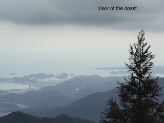
The route followed the road and a gurgling stream for a while. In many places the road was icy as when I went back into the forest the stretches of ice became more extensive. The path rose and fell, with steps and rocks, until about 5 kilometres from the end there was a viewpoint where I saw the coast for the first and only time.
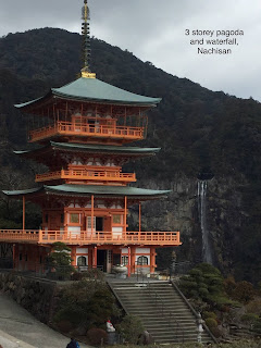
The gradual descent to Nachisan was welcome. The path came out into a huge open area of grass then went back into the forest for the final kilometre. The steps down to the finish seemed endless, and the finish itself, by the Nachisan temple grounds (Kumano Nachi Taisha), was quite an anticlimax. There were several temple buildings and a nice red pagoda, but the main shrine was under renovation and was covered by white cloth. I could see the Nachi waterfall not far away, the highest in Japan.
I caught a bus to Kii Katsuura (on the coast) from near the waterfall. I was delighted to discover that Kii Katsuura has the biggest and best tuna fishery in Japan, and consequently dozens of tuna restaurants. I was also pleased to find the town has several foot spas and I made good use of them.
And that is the story of my 70 kilometre hike. 楽しみました!
I made a wallhanging based on a plaque I had seen along the trail.


No comments:
Post a Comment